
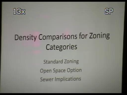
PUDs and Density Bonuses Examined at March 4, 2015 PC
In March, 2015, Carlisle-Wortman Consultant Doug Lewan was our Township Planner.
At this meeting Lewan delivered a quick survey of the available options for developing an 80 acre parcel of land, constrained by Northfield Township zoning and land use regulations.
Below are the screencapped illustrations and my transcription of his brief lecture.
Five years have passed. I do not know if these options remain valid options.
[Beginning of Transcription]
Doug Lewan: "At one of the last meetings we talked about making sure the planning commissioners understood about, and this goes along with our previous discussions, about densities and things like that. So at our last meeting, or a few meetings ago, I brought up the point that, perhaps, the planning commissioners can't visualize, necessarily what's permitted in our zoning ordinance and how our open space provisions work and how various projects might occur on property. And I'll hit this stuff here. I was going to hand this out. I was going to email this to everyone before hand so if you don't have it, I've got copies.
[Click Read More for the rest of the presentation and 13 slides]
Ok, so, again, I thought it was important to kind of go over our current zoning about what things might actually look like if they were developed. So, let's first start with, let's talk about an 80 acre parcel, because, 40 acre parcels are still pretty common in the township and so with two 40s, you get to an 80.
[Option 1]
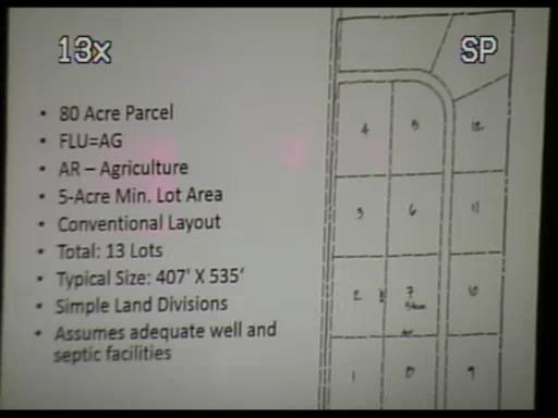
And so that shape on the right is to scale and that would represent an 80 acre parcel. So if you were to look at an 80 acre parcel in Northfield Township and someone were to do the quickest way to develop a property they could come up with approximately 13 homes. And that would be based on what's permitted in both the Township Zoning Ordinance and not only the Township Zoning Ordinance but the Land Division Act, which allows a certain number of splits for a certain size property. So in this particular, if you go down the list of bullets there we've got an 80 acre parcel, that's Master Planned, the FLU stands for Future Land Use, so the Master Plan would be Agriculture, the Zoning is also Agriculture, AR = Agriculture, the 5 acre minimum. This would be a conventional layout. You get about 13 lots. 5 acres each. A property owner could do simple land divisions in this case. So what that means is that there are three ways you can divide property. There's simple land division; there's platted subdivision, and there's site condo. Simple land division is the easiest way to divide property.
And it's done administratively. It's actually just done here downstairs at the Township offices. You wouldn't have to come to the planning commission. The only thing that would have to come to the planning commission here for is the private road. So the road that you see hooking to north and then to the west would be, well it could be a private road, because that could be, would be the most inexpensive way to build this, and so you would have a developer would come in with a private road. We would review the private road but that's all we would review as a planning commission. Otherwise the divisions could just be made to the assessor and to the zoning administrator and they coulod be approved so this would be the easiest and the quickest way o fproperty owner, if they just wanted to get some splits they could get some splits, generate some income on their property, sell home sites.
In this, however, there are assumptions. All these examples I give you are maximum examples. So this assumes that soils are good enough for 13 home sites for septic systems, that's there are well locations, and that there's no really significant natural feature here, like a big wetland, that couldn't be developed to a certain degree.
[unintelligible question re septic systems, engineered fields, decent soils...]
We're assuming on this, This case assumes adequate septic facilities, however you get there. Adequate septic facilities. So well and septic... So you get thirteen. So an 80 acre parcel you get 13 big lots. By the way this would not be something we would recommend. This is the, this is the bad example of development where you've got a house on five acres and these people, some of these people might maintain five acres in lawn or who knows what they're doing. This is not what we want. But you could do it. We couldn't really stop you from doing because this is allowed based on the land division act.
So, next step, we're going to get progressively more dense on this 80 acre parcel based on Master Plan and zoning and some of the options that we have available to us in Northfield Township. So this plan shows the base 13 unit density.
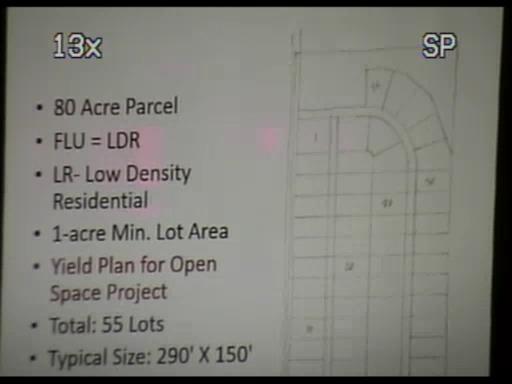
[Option 2]
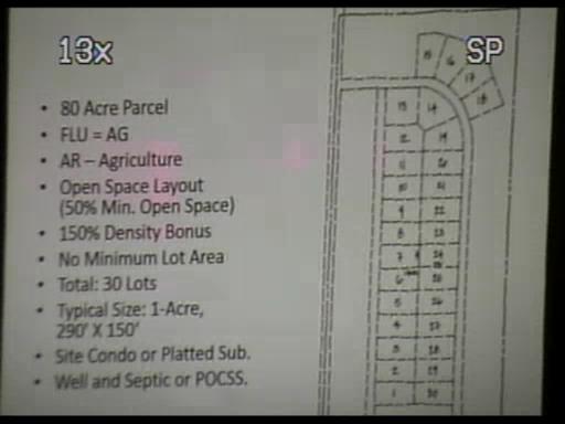
Now, same 80 acre parcel. In this particular case, again, Master Planned Ag (FLU=AG) Zoned Ag (AR) This is now an open space project. So this is a project that allows for some density bonus if a developer was to maintain 50% open space. This actually scales out at 50% open space. Again, this is just an example. Of course a developer would probably do something much more creative or maybe less creative. But in any event, this would represent 50% open space with what our ordinance now allows an open space development is a 150% density bonus if you're able to accomodate 50% open space plus some other things. So assuming a developer could get his total density bonus of 150% you could get about 30 lots on a piece of property zoned agriculture, planned agriculture, on, and we estimate, just our little calculation we did here indicated these could be 1 acre lots.
Now, on 1 acre lots, as someone mentioned, I don't know if it was Brad or Howard, mentioned today, the health department generally speaking, allows septics to go on one acre lots. So if this again had great soils, yeah, minimum lot size for septic, if this project had great soils, you could get, in theory, 30 homes on septics on one acre lots without having to change the zoning or have to deal at all with the master plan and you could do this... in this case now you do have to take a jump and now what's in front of the planning commission cause one, it's an open space project, which is a conditional land use, and so, we have, so, now there's a public hearing involved and we get more, we of the planning commission get more involved in this process, and you can't just do simple land divisions now. Because you're beyond the number that's allowed in the land division act.
So now you have to develop this as either a site condominium, which is probably what 99% of all new development is going to be in Northfield Township, or it could be a platted sub. Platted subs - people just aren't doing them because it takes way to long to get through the process. Pretty much most residential development is gonna be a site condominium.
So in any event you have to use site condo. This assumes good well and septic or a Private On Site Community Septic System or POCSS is what the county health department calls them. And they would be involved, the county would then be involved with permitting the POCSS; we... our ordinance allows them but we pushed that permitting off on the county. So we review the site plan, we review the circulation, we review the all of those things that go into this to make sure it meets their open space project standards but when it came to the onsite sewage plant, that's an option; it's an option allowed in our ordinance, they would have to meet the county standard. So...
[unintelligible questions]
Yes...
[unintelligible questions]
Yeah, well the previous... it's 150% more than this [returns to Option 1, 13 lots] So that plus 150%... Add on to that number, yeah, yeah, add it to that, [unintelligible] 30... 30
So this is what you get with your density bonus or you could potentially get an AG zone with no changes to our, to the master plan or the zoning or with anything. So now let's look at, again, assuming there's no giant wetlands or anything like that, which really can throw things off by the way,
[Option 3]
So let's get into now a different scenario, a different master plan category with a different corresponding zoning designation.
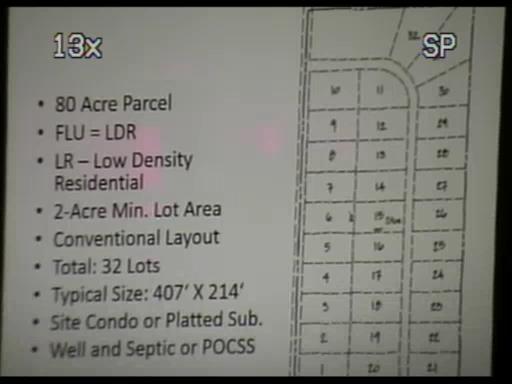
Master Plan - Future Land Use: FLU=LDR
Zoning: LR - Low Density Residential
So the master plan category in this case would be LDR, low density residential, the zoning, corresponding zoning designation would be LR, which is low density residential, with a 2 acre minimum. SO that's the same category same number of lots between the master plan and the zoning ordinance. We have a two acre lot layout. This is a conventional 2 acre lot layout. Each one of those lots is 2 acres. You get about 32 of them. In this case because the uh uh, these are actually turn out to be about, oh, these are 2 acres each... so again, in theory, if you have great soils you could still do well and septic, or if they didn't have such great soils you could do a private on-site sanitary system.
Again, you're doing a site condo or platted subdivision again this is not a desireable solution because the whole property is being used in lots and yards and ... our master plan and our zoning advocates for open space projects that would cluster these developments. But this is a key, this is key like the others we have to know what is our starting point. What's our starting point in a conventional develpment that would be zoned LR
[Option 4]
So now we get into the same thing zoned LR master planned LR 80 acres. THis sketch here represents a... what we call a yield plan or a parallel plan. THe LR's a little different from some of the other zoning districts in that it allows you to calculate density if you're doing an open space project based on one acre lots, so it's as many one acre lots as you could get in here is the number of lots you could get for an open space project in the LR district. SO we calculate, and the area up to the north of this we just calculate like storm water detention... there's gotta be something taken away for storm detention and like that, again, just as an example, so you can kind of get a feel for density,
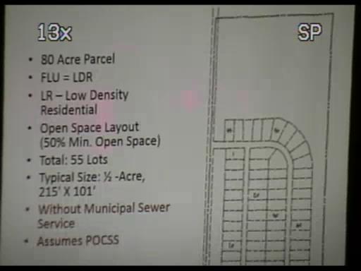
[Option 5]
so in this particular case, in a project without municipal sewer service, you get that calculation, if it's an open space project, and you have 50% open space, um, you can calculate the total number of lots, this is the key is the density, at one acre lots, so we don't really want one acre lots but if a developer has an 80 acre parcel and they wanna see how many they can get they've gotta provide a plan like this that shows how many one acre lots you can get and then they would convert that to something like this [Option 5]
And so in the previous example [Option 4] you saw 55 lots is what we could get. So then they convert this to 55 lots [Option 5] on 80 acres with 50% open space. This gets the lots down to about a half acre with 50% open space. Now because we're at a half acre we're away from the potential of on-site septic and so now we have to, the only way this works is if we, with a private on-site community septic system (POCSS).
[unintelligible question]
Well there is a bonus because the bonus is LR is a 2 acre minimum straight. If you are gonna do an open space project with a 50% open space you can calculate, for the purposes of density is what the ordinance says, you can calculate the number of one acre lots you can get on the same property, and so, that gets up to 55 instead of 32 [Option 3] if you were to develop it conventionally. So there is a bonus for LR.
[unintelligible]
Yes. That's definitely... The main benefit of a cluster project. Let's assume the north part of this project was a beautiful woodland that we didn't want to be touched. Well, that's really the purpose for a cluster is that you would leave that woodland open. Maybe there are some wetlands up there. Who knows what? Steep slopes... Something that you wanna preserve. So... the whole idea of a cluster is that you cluster the homes on the part of the property that's least sensitive and you leave open the part of the property that's most potentially sensitive. So again, I'm sure that the planning commission and I didn't even, once we started putting this together it became quite apparent to me that there's quite a bit more density potential even with property zoned LDR or LR or even Ag zoning as far as that goes so this was a little eye opening. I kind of did the calcs on that table I gave you and this follows that pretty closely but this is a little eye opening to me as well.
[Option 6]
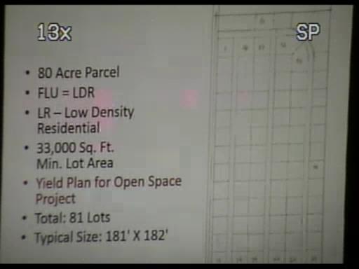
So now the final thing in the LR... There's three different ways you can do density in the LR. This is if you are on municipal sewer so if you're on municipal sewer in the LR district remember the one layout was to figure one acre lot size. Well in the LR, if you're within the sewer service district, you can come up with this yield plan or a parallel plan showing 33,000 square foot lots, which is a little under an acre, so you're gonna get a few, you're gonna get more homes. We in fact, we figure that in this case with a 33,000 square foot lot, now, this is zoned LR, a developer could get somewhere in the neighborhood of 80 homes.
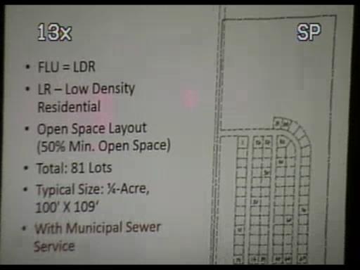
[Option 7]
And then if you do an open space with this project, now we're down to quarter acre lots, 81 homes, quarter acre lots, still 50% open space. And so really what we're trying to do is preserve open space here. Really the density between 81 and 55 [Option 5] becomes much less... or 55 becomes really less relevant. In fact if you drove through this subdivision you might not even be able to tell that these are [Option 6] half acre lots as [Option 7] opposed to quarter acre lots. Uh, So, this is with sewer service though, this is how the ordinance is currently written. So this is, this is, again, just an example. These numbers would likely go down in the real world once we start calculating for natural features on a site. I just wanted again to show you total possible density.
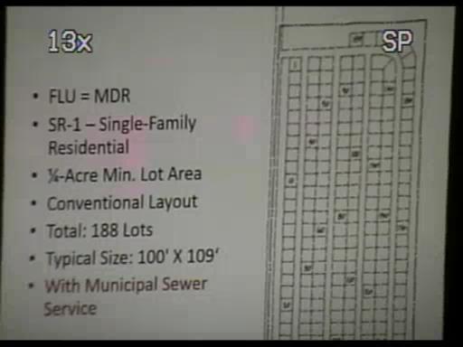
[Option 8]
Now the last example is [Option 8] MDR. And this is just straight quarter acre lots. So, future land use (FLU), this would be medium density, SR-1 would be the designation... this would be a quarter acre lot minimum from if you remember in this example [7] we got down to quarter acre lots but you still had to base your density on this [Option 6]. In this case [Option 5] we got down to half acre lots, but you had to base your density on [Option 4] this. In this case, [Option 8] in the MDR example, it's simply quarter acre lots, and that's the density. Now you could still do... I don't have another example after this, but I just wanted to get to this point, and show you the potential numbers, about 188 lots or so, on a property zoned MDR, same number of acres, so you've got 80 acres, you're up to 188 units, and even in this case we would likely advocate that the applicant cluster in some manner.
[unintelligible] This would likely not look like this in the final analysis but the advantage for the developer obviously has an MDR zoned piece of property is they've got a lot more density to work with. They've got 180, say, 170 to 180 units, however many they could get there and then they can configure those in a hopefully more creative way.
[Option 7] Where when you get under the LDR you're limited to 81. You can be creative with that.
[Option 5] And then with no, without sewer you're limited to 55.
[Option 3] And then, uh, standard 2 acre you're at 32
[Option 2] And then again, the uh, Ag open space is uh 30.
[Option 1] And then the standard is 13. So you can see the progression that we, that... we're discussing the master plan and it's good to kinda get this, uh, these numbers in your head, what the implications might be, and/or, you know, the potential for a certain piece of property, with and without sewer, based on open space, based on all of those factors... So, I don't know, I hope this helps a little bit. It helped me when I did it. Um.. I also have one other thing that's kind of related to this... We asked uh Mark asked, and I think another couple of commissioners asked for um I feel like Phil Donahue walking around here with the mic... um [laugh] Yeah, Mark asked for a and I've got a big board I'll talk about... I'll leave one for Howard as well. I'll grab one for later too.
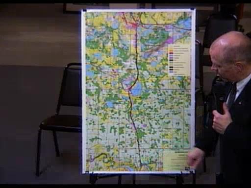
SEMCOG Land Use Map - US 23 Corridor
So you guys have the drawing and uh basically there is a request to look at what amounted to be kind of development patterns... I think is kind of what we're looking at here. What were the development patterns along US-23 and sort of how does Whitmore Lake and the Northfield Township area relate to the development patterns on 23 really from M-14 to the south to 96 to the north... And... this is a map provided by the Southeast Michigan Council of Governments that is the uh existing land uses...
So this map really shows land use patterns. What you should be looking for if you're interested in like residential density or commercial, residential density particularly, will be looking for the yellows and the oranges on this map. Commercial will be the red. And then the blues for the industrial and that sort of thing.
So, because the scale got so big, because it's such a big area, it is admittedly a little hard to see some of the things, but you can see sort of a pattern of residential development and of course you see it on Horseshoe Lake in Northfield Township and then around Whitmore Lake and then as you get North on up towards and into Green Oak Township and into Brighton that gets much more pronounced and so there obviously is a more residential development that is, uh, occuring in the US-23 corridor, particularly as you head toward Brighton, not as much as you head South.
Of course if you look at the M-14 intersection, yes, there is obviously development there. Um. But this is again, hopefully, something that can help you guys think about, uh, as we get into this more detailed discussion of the Master Plan and how, uh, I know we were concentrating our conversation with the area at Whitmore Lake down to Joy Road, but perhaps we look at more this as a global view now of the Township and of the surrounding communities and so I wanted to present that I don't really have a whole lot else to say about this at this point.
If there's any questions I'll try to answer about the data and anything. This data is a little bit dated because SEMCOG's changed the way they present this information. And they now, the information SEMCOG presents now is much less useful because the map now, the colors, this is based on actual land use, based on aerial photographs and things like that, and even though the data's a bit old it does give you an idea of what's going on here in the corridor.
SEMCOG now uses assessing data and it's very... the map makes no sense, in my opinion, the map makes no sense and it looks like there are wide swaths of residential property when you know there's nothing there. It looks like there's wide swaths of commercial property when you know there's nothing there. But they've put together their new maps that I don't even put in our master plan but I still try to use this. It's just not useful. And I printed one out today and I don't even want to bring it because it's just not helpful. It looks like almost the whole township is residential and everywhere in this whole map is residential and commercial and industrial. So, uh, anyway, I hope this is a good starting point. There may be additional sources out there that we can bring into this as we get deeper into this discussion. but this is, this is really kind of the first, the first step into this. And I was kind of encouraged even to be able to stitch all this together with the surrounding communities. And um SEMCOG, while I don't like the way they currently do existing land use using assessing data, they do have an awful lot of data layers that we can use. And if you let me know what you want to see, we can probably light that up on a paper like this.
So [unintelligible question] We have access to it; I don't think you can get to it. I'm sure, we have some kind of subscription I'm sure.
[Chockley]
Is Northfield Township a member of SEMCOG?
This presentation may be watched as part of the March 4th P.C. meeting here on Livestream.